


9 km | 10.6 km-effort
![Trail On foot Rožmitál pod Třemšínem - [Z] Hutě pod Třemšínem - Břízkovec - Photo](https://media.geolcdn.com/t/1900/400/995d403a-75fd-4dbb-a506-7766fe4a4a40.jpeg&format=pjpeg&maxdim=2)

Tous les sentiers balisés d’Europe GUIDE+


FREE GPS app for hiking
 SityTrail
IGN / Geographical institutes
SityTrail World
The world is yours!
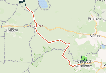
Trail On foot of 9 km to be discovered at Central Bohemia, Unknown, Rožmitál pod Třemšínem. This trail is proposed by SityTrail - itinéraires balisés pédestres.
Trail created by cz:KČT.
cesta byla zkrácena a nyní končí u PB347 (Uhelnice). Na tomto rozcestníku je 2017-05 ještě špatná pokračovací šipka
![Trail On foot Rožmitál pod Třemšínem - [Z] Hutě pod Třemšínem - Břízkovec - Photo 1](https://media.geolcdn.com/t/2048/auto/1e8c8171-5f53-4f6d-9c1c-7a17680d16fe.jpeg&format=jpg&maxdim=0 "Trail On foot Rožmitál pod Třemšínem - [Z] Hutě pod Třemšínem - Břízkovec - Photo 1")
![Trail On foot Rožmitál pod Třemšínem - [Z] Hutě pod Třemšínem - Břízkovec - Photo 2](https://media.geolcdn.com/t/2048/auto/fb315081-9ebb-418a-a566-f48f045abefb.jpeg&format=jpg&maxdim=0 "Trail On foot Rožmitál pod Třemšínem - [Z] Hutě pod Třemšínem - Břízkovec - Photo 2")
![Trail On foot Rožmitál pod Třemšínem - [Z] Hutě pod Třemšínem - Břízkovec - Photo 3](https://media.geolcdn.com/t/2048/auto/311ce936-8af1-4a8d-9eea-2aadb737b793.jpeg&format=jpg&maxdim=0 "Trail On foot Rožmitál pod Třemšínem - [Z] Hutě pod Třemšínem - Břízkovec - Photo 3")
![Trail On foot Rožmitál pod Třemšínem - [Z] Hutě pod Třemšínem - Břízkovec - Photo 4](https://media.geolcdn.com/t/2048/auto/0fe1c8b6-6c71-40ec-8959-ba70d0ad3468.jpeg&format=jpg&maxdim=0 "Trail On foot Rožmitál pod Třemšínem - [Z] Hutě pod Třemšínem - Břízkovec - Photo 4")
![Trail On foot Rožmitál pod Třemšínem - [Z] Hutě pod Třemšínem - Břízkovec - Photo 5](https://media.geolcdn.com/t/2048/auto/2bb44d8f-6c39-4261-ae7a-2e372009ca44.jpeg&format=jpg&maxdim=0 "Trail On foot Rožmitál pod Třemšínem - [Z] Hutě pod Třemšínem - Břízkovec - Photo 5")
![Trail On foot Rožmitál pod Třemšínem - [Z] Hutě pod Třemšínem - Břízkovec - Photo 6](https://media.geolcdn.com/t/2048/auto/617fd336-1e6d-4d31-b841-ac850a32f816.jpeg&format=jpg&maxdim=0 "Trail On foot Rožmitál pod Třemšínem - [Z] Hutě pod Třemšínem - Břízkovec - Photo 6")
![Trail On foot Rožmitál pod Třemšínem - [Z] Hutě pod Třemšínem - Břízkovec - Photo 7](https://media.geolcdn.com/t/2048/auto/415d0d9c-3d0d-4500-a7fc-5fa67a7fa8d4.jpeg&format=jpg&maxdim=0 "Trail On foot Rožmitál pod Třemšínem - [Z] Hutě pod Třemšínem - Břízkovec - Photo 7")
![Trail On foot Rožmitál pod Třemšínem - [Z] Hutě pod Třemšínem - Břízkovec - Photo 8](https://media.geolcdn.com/t/2048/auto/30fa0950-62bb-4040-bbed-75329bdebbbe.jpeg&format=jpg&maxdim=0 "Trail On foot Rožmitál pod Třemšínem - [Z] Hutě pod Třemšínem - Břízkovec - Photo 8")
![Trail On foot Rožmitál pod Třemšínem - [Z] Hutě pod Třemšínem - Břízkovec - Photo 9](https://media.geolcdn.com/t/2048/auto/171fe3b8-2305-4d0d-9781-b0684536a718.jpeg&format=jpg&maxdim=0 "Trail On foot Rožmitál pod Třemšínem - [Z] Hutě pod Třemšínem - Břízkovec - Photo 9")
![Trail On foot Rožmitál pod Třemšínem - [Z] Hutě pod Třemšínem - Břízkovec - Photo 10](https://media.geolcdn.com/t/2048/auto/995d403a-75fd-4dbb-a506-7766fe4a4a40.jpeg&format=jpg&maxdim=0 "Trail On foot Rožmitál pod Třemšínem - [Z] Hutě pod Třemšínem - Břízkovec - Photo 10")
![Trail On foot Rožmitál pod Třemšínem - [Č] Rožmitál p. T. - Třemšín - Photo](https://media.geolcdn.com/t/375/260/0689d70f-e711-4fe9-af24-fb32614d9884.jpeg&format=jpg&maxdim=2)
On foot
![Trail On foot Věšín - [Ž] Varta - Třemšín - Photo](https://media.geolcdn.com/t/375/260/f1b092e8-e85a-4488-b770-d743603f9f8f.jpeg&format=jpg&maxdim=2)
On foot
![Trail On foot Rožmitál pod Třemšínem - [Z] Rožmitál pod Třemšínem - U Padrťských rybníků - Photo](https://media.geolcdn.com/t/375/260/34eeebef-983f-4f05-9d42-741890d7d34c.jpeg&format=jpg&maxdim=2)
On foot